Forecast for the Moab Area Mountains

Eric Trenbeath
Issued by Eric Trenbeath on
Sunday morning, April 6, 2025
Most terrain has generally LOW danger this morning. Small avalanches on isolated terrain features are possible. Even a small avalanche can have serious consequences in extreme terrain.

Under a strong sun today, the danger will rise to MODERATE for loose wet avalanches on steep, sun exposed slopes. Signs of instability include rollerballs, pinwheels, and sloppy wet snow. Stay off of and out from under steep slopes when these signs are present.
Our long standing persistent weak layer problem appears to no longer be reactive and people are skiing all kinds of terrain without incident. Cautious mountain travelers will nevertheless continue to avoid likely trigger points such as shallow rocky starting zones, thin steep convexities, and areas of very radical, extreme terrain.
Low
Moderate
Considerable
High
Extreme
Learn how to read the forecast here
Special Announcements
No construction today and the road will be open.
Geyser Pass Road: The road has not been plowed and is a bit sporty, especially on the upper half with ruts up to a foot deep. 4x4 required.
Grooming Conditions: Trails are packed into Gold Basin.
Motorized Users—Please consider taking this 5-minute survey to help researchers better understand avalanche education participation and safety preparedness. Responses are anonymous and confidential. Thank you!
Weather and Snow
6 A.M. Snow and Weather Data
24 Hour Snow: 0" 72 Hour Snow: 6" Season Total Snow: 138" Depth at Gold Basin: 52"
Winds on Pre-Laurel Peak: NE 5-10 G 30 Temp: 14° F
Weather
High pressure builds over the region today with a gradual warming trend in store for the upcoming week. Look for sunny skies today, light to moderate northeast winds with occasional strong gusts along ridge tops, and high temperatures in the mid to upper 30's. Temperatures tonight drop into the low 20's. High temperatures tomorrow will be in the low to mid 40's.
General Conditions
The first week of April brought great conditions to the La Sals and people have been getting after it. All told, we picked up 18" of snow last week and the mountains look as white as they've been all season. A several hour period of strong northeast winds on Friday night affected the snow surface a little on upper elevation northerly aspects but yesterday, my partner Dave Garcia and I still found conditions up there to be more than acceptable. Sunshine and warm temperatures cooked the snow on all sun exposed slopes and they will be thoroughly crusted over this morning. It does look like we have a good melt/freeze cycle ahead and we should get some corn-like conditions in a few days.
People have been getting into all kinds of terrain without incident and it appears that the snowpack is mostly stable. There may still be a few errant wind slabs up high that could be sensitive to the weight of a skier or rider. Avoid smooth rounded pillows of wind drifted snow, especially in areas of consequential terrain. Layers of weak faceted snow still remain on northerly aspects but a strong, hard slab exists over top and triggering an avalanche down to these weak layers has become very unlikely. Nevertheless, whenever I travel in the mountains, I keep my avalanche glasses on. Travel with awareness and avoid thin rocky areas and obvious trigger points such as steep convexities and blind break-overs.
The snow surface up high has been slightly wind affected but the turning conditions are still pretty good.
Snowpack and Weather Data
Gold Basin SNOTEL site (10,000')
SNOTEL site near Geyser Pass Winter Trailhead (9600')
Wind Station on Pre-Laurel Peak (11,400')
NWS forecast for the La Sal Mountains.
Recent Avalanches
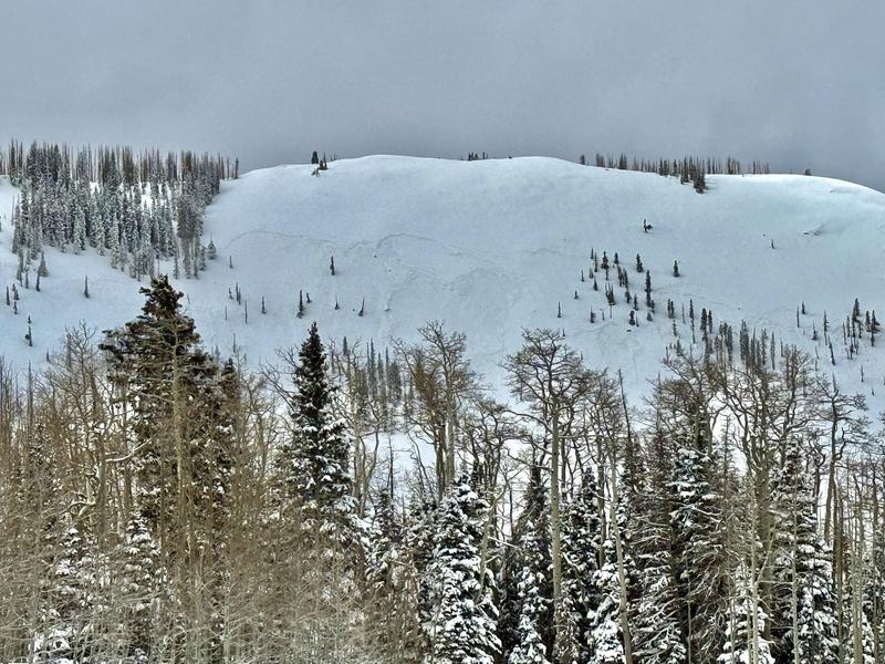
We experienced a pretty good round of natural wind slab avalanche activity during the recent storm cycle with some breaking quite wide, and nearly all running far on the slick hard surface underneath. Most occurred on steep, northerly aspects above treeline. Of all the avalanches reported, this very wide slide observed by Tim Mathews on Noriega's Face is perhaps the most impressive.
See the complete avalanche database here.
Ad
Avalanche Problem #1
Wet Snow
Type
Location
Likelihood
Size
Description
Expect the danger to rise for loose wet avalanche activity on steep, sun exposed slopes. The danger follows the sun starting first on east, then south, then west facing slopes. Signs of instability include rollerballs, pinwheels, and sloppy wet snow. Stay off of and out from under steep slopes when these signs are present.
Additional Information
Check out the latest UAC podcast with forecaster Brett "Kowboy" Kobernick where he discusses faceted persistent weak layers and how "nobody is immune from getting killed in an avalanche."
Sign up for text alerts to get the most up to date information about changing conditions, road plowing, special avalanche announcements.
Follow us on Instagram @utavy_moab
General Announcements
This forecast is from the U.S.D.A. Forest Service, which is solely responsible for its content. This forecast describes general avalanche conditions and local variations always occur.